If you are curious about the details of your property or a property you are interested in buying, you can look up the property on Nevada County’s GIS on the county’s website.
The county has a transparent, open access database with detailed information on property structures, local service districts (i.e. local provider of water, utilities, sanitation, fire safety, etc.) permits, official documentation, zoning, and much more.
All you need is internet connection and an address to access the Nevada County GIS database! Go to the Nevada County GIS home page, and under the Value tab, simply type in the street address of the property you are looking for in the search dialog box. A map of the parcel will appear, with a red line indicating the property boundaries. See photo below of our the GIS map of the business park where our office is located in Grass Valley.
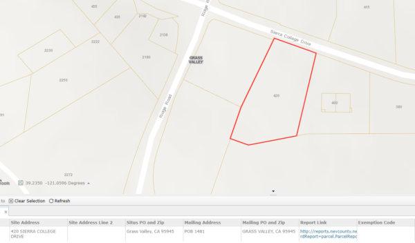
The search results include APN (Assessor’s Parcel Number), Gross Roll Value, Tax Area Code, and Assessed Acreage.
Under Report Link, click on the link to view detailed property information. The report is divided into the following categories, with detailed data about the site, including site specifications, real estate value, zoning codes, and permits:
- Site Information – This section contains legal, geographic, and zoning information about the property. This section includes site address, jurisdiction, legal description, subdivision, zoning, and property context.
- Property Details – This section contains information about site infrastructure and existing structures. In this section, you will find information about structures, layout, amenities, infrastructure, and land characteristics.
- Districts – This section contains information about utility and public services. In this section you will find out what school district, fire department, water, and utilities serve the property location, as well as the sanitation districts and political districts that serve the location.
- Permits – County permit information is only available for certain addresses (usually those outside of the city limits). This is a very valuable resource, because it allows you to determine what permits apply to existing structures, and which permits are missing. You can click on the building department permit number (starting with the last two digits of the year it was issued) of any permit.
The permit link directs you to Nevada County Building Department’s permit webpage, which provides downloadable official permit documents for each construction project, and information on permit processing status (from various different departments) and all inspections that were carried out.
- Unrecorded Maps